Nor'easter during hurricane season: it's crazy weather for sure
It’s not going to give you the forecast for what’s coming weather-wise, but it might explain how things go around our region when it comes to storms.
It was almost 10 years ago when one of the higher-up bosses a The Pilot asked anyone who was available to head out, get stories and take pictures of the aftermath of a strong storm system that had skirted our coast.
I don’t remember if it was a nor’easter or a tropical cyclone, but it had caused some significant flooding throughout Hampton Roads. Trees were down and electricity was out.
Powerful northeast winds had combined with high tides and lots of rain to leave much of the area afloat.
Knowing that I lived in northeastern North Carolina, I was called on to get some stuff from somewhere around the shores of the upper Currituck Sound.
I headed into Tull’s Bay, southeast of Moyock.
After driving around some pools of water and through a few others, I came up on a small marina and boat ramp in the midst of a small neighborhood. The woman there was super nice and gave me some comments I would need. Growing up in Back Bay and the Sound, I knew the rest.
A few photographs later and I was off and running back home to write and process so I could make the paper’s online version quickly.
Trouble was, all the boats I took pictures of were resting on the muddy bottom of neighborhood canals.
Three to four feet of water had been blown out by strong northeast winds. Back Bay was mud as far as the eye could see.
Meanwhile, sections of Hampton Roads were swamped.
Which that presented a major problem at work. Editors didn’t understand that northeastern winds blew water into Hampton Roads and out of areas to the south - from the Great Bridge Locks on down.
They didn’t believe me and wanted to argue about it.
When they finally realized they were off the charts wrong, it was too late. My stuff didn’t make the paper or online, and none of them offered an apology.
But it’s all good. Kind of like water under the bridge, of which there was none.
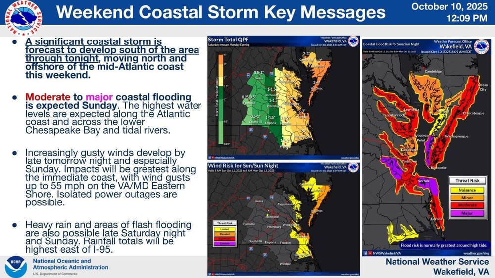
So that brings us to this weekend and the nor’easter forecast to blow into the area with high winds, several inches of rain and plenty of flooding.
During Friday morning’s weather briefing by the National Weather Service’s Wakefield office, it was noted that this low pressure system was going to be moving slower than predicted and that winds would be slightly less powerful.
Trouble with the forecast was that the system likely would have ample time to pile up water in Hampton Roads. Mix in a higher than normal King Tide and you have all the makings for moderate to major flooding - especially in areas prone to such things.
Rainfall could be slightly less, mainly in the 2- to 3-inch range with some spotty areas of more.
Things are supposed to ramp up sometime after lunch Saturday, with that night and all day Sunday being the worst.
There also will be high seas building and that spells beach erosion - which means real trouble to Buxton and Rodanthe on Hatteras Island.
In the last 10 days, eight beach houses in Buxton fell into the pounding surf. One tumbled into the water in Rodanthe. All were caused by rough surf from passing hurricanes and tropical storms.
Several other houses appear to be extremely close to joining in.
As we get closer to the Atlantic Hurricane Season’s end-of-November conclusion, this storm without a name still will cause problems in many areas - leaving many waterlogged.
But as I’d like to tell that editor one more time, northeastern North Carolina won’t be one of them.