Erin is a big, nasty Cat 5 Hurricane ... so what's that mean for us?
So here’s where we were as of the National Hurricane Center’s 5 p.m. update on Saturday.
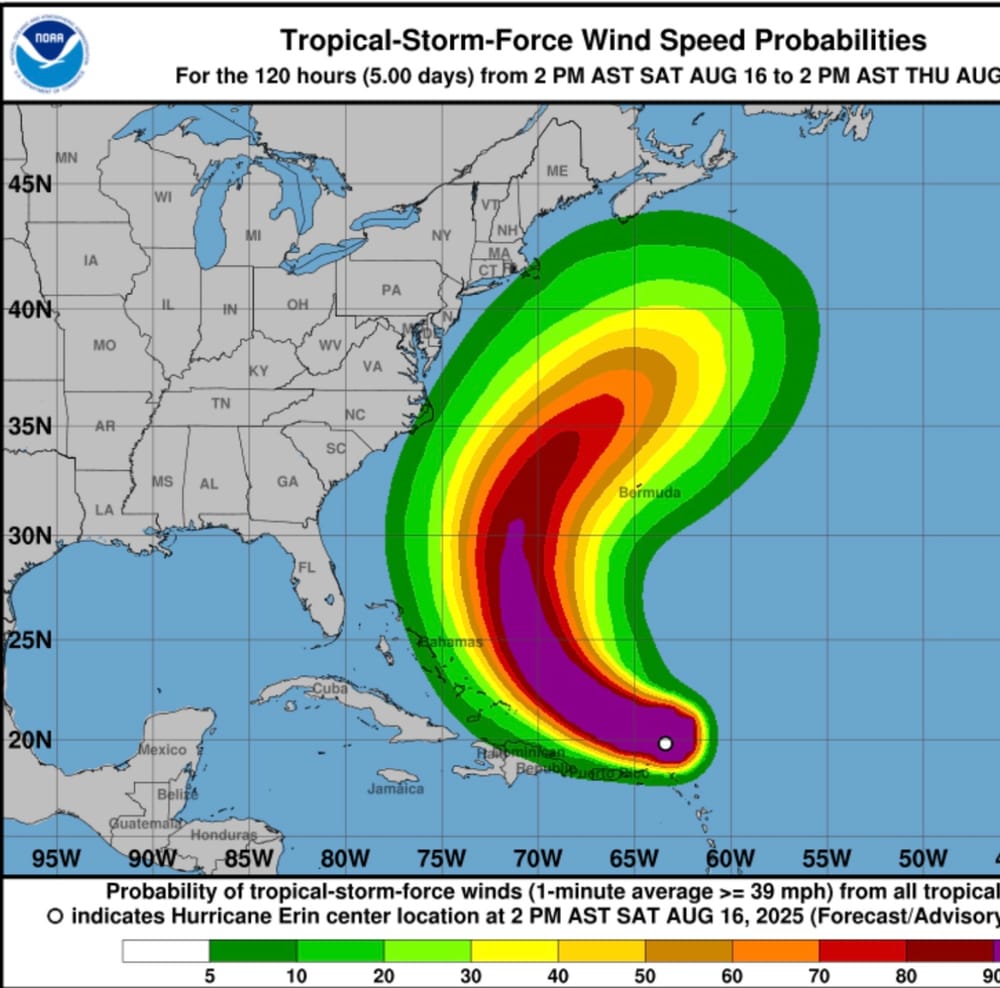
Erin is an extremely dangerous Cat. 5 cyclone with winds of 160 mph. It’s moving west at approximately 15 mph.
The good news is that computer generated forecast models are all in agreement that the system will begin to slow down as it turns to the northwest and eventually north - missing both the East Coast and Bermuda even though models have it slightly west of previous forecasts.
There also is a high degree of confidence that the steering patterns will accomplish this switch in direction.
The storm also appears to be going through an eye wall replacement, which is common with a powerful system that slows down its forward speed.
And as it slows for several days, the storm field is expected to expand by twice to three times its current size.
So what’s it all mean for us?
Plenty.
For starters - and folks in the know have been screaming about for days - make sure your hurricane plan is at the ready and needed supplies are stocked.
Be ready to vacate inland if necessary.
Even if the system falls to a Cat 3, a direct hit on our region would be devastating. All the stuff you see on the news and weather channels would happen here.
Massive devastation. No joking.
But since we’re looking at a high chance that won’t happen, it’s a good time to practice your readiness. Unfortunately, most people won’t.
It is what it is.
Time for a little good news.
Erin will bring intense, damaging and high surf to the shoreline of our region. That could be good news to certain divisions in the upcoming East Coast Surfing Championships that will be in high gear during the storm’s passing. That, however, means that competition for the young and new surfers likely will have to take place on the event’s first day, or not at all. Forecasters at the National Hurricane Center say conditions could be “life threatening.”
While the surf will be high, it will be sloppy and choppy with no offshore winds to clean it up.
Organizers are waiting to make any announcements.
For the casual beach-goer, rip currents will be extremely dangerous. Watch in amazement, but stay out of the water.
Another big event for the week is the Virginia Beach Billfish Tournament.
Forecasters are calling for swells between 10 and 20 feet offshore, meaning it’s probably going to be too dangerous for some teams to venture out.
Again, organizers are waiting to make any announcements.
So stay tuned. The area almost definitely will see bad beach erosion and high tide flooding throughout southeastern Virginia. Northeasterly winds will blow water out of Back Bay, Currituck Sound and tidal systems that dump into both.
Forecasts for rain amounts and wind speeds will start hitting the presses beginning the first of the week, but both can be expected from the cyclone’s outer bands.